Planning Process
The NM Bike Plan prioritizes State-owned roadways based on their appropriateness for bicycle infrastructure and creates a series of bicycle-friendly roadway design guidelines (e.g. wide shoulders, bicycle lanes, or separated trails). The Plan will help guide roadway improvements and incorporate bicycle infrastructure on NMDOT roadways as they undergo regularly-scheduled maintenance as well as major reconstruction.
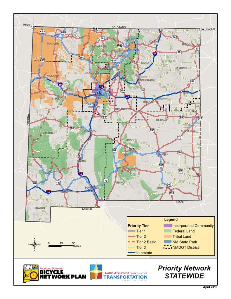
To determine the Statewide Bicycle Network, the Project Team conducted analyses related to equity, potential demand for bicycle infrastructure, access to public transit, and connections to existing bicycle facilities, among other factors. This information, along with feedback from the public and interested groups around New Mexico, help to determine the locations where improved bicycle infrastructure will be most beneficial.
Design guidelines are created that identify the appropriate types of bicycle infrastructure for roadways in the statewide bicycle network. The guidelines vary depending on whether the roadway passes through urban or rural areas. See the Frequently Asked Questions below for more information about the Design Guidelines.

Frequently Asked Questions
1. When will construction of bikeway infrastructure improvements take place?
Improvements to bikeway infrastructure will be incorporated during roadway construction projects and considered during regularly scheduled maintenance.
NMDOT and/or local agencies may choose to pursue stand-alone bikeway improvement projects.
2. Do the route tier assignments indicate priority levels?
The route tier assignment proposed in the NM Bike Plan assigns roadways to one of three tiers, which indicate the robustness of the proposed bikeway infrastructure rather than the order of implementation. This approach is necessary as NMDOT has limited financial resources available to maintain the state roadway network, and resources need to be thoughtfully prioritized to improve the bicycling experience on state roadways.
3. What are the route tier assignments?
• Tier 1 Routes – High Priority Bikeways
Tier I routes are high priority bikeways that provide critical intra-urban and statewide connections between New Mexico’s communities and for cross-state travel. Tier 1 routes exhibit high existing or latent demand for bicycling, and are highly appropriate for implementation of bikeway facilities. These facilities may appeal to recreational and utilitarian cyclists and demonstrate high tourism potential and recreational demand. Tier 1 routes are typically high-volume and/or high-speed roadways where additional separation between cyclists and motorists is desired.
• Tier 2 Routes – Medium Priority Bikeways
Tier 2 routes are medium priority bikeways that exhibit existing or latent demand for bicycling and are appropriate for the implementation of bikeway facilities. Tier 2 routes typically provide long-distance or statewide connections and may appeal to recreational and/or more comfortable utilitarian cyclists. Alternative routes to Interstates are typically designated as Tier 2 facilities.
• Tier 2 Basic
Among the Tier 2 facilities is a special category of roadways that have been identified as important bicycle connections and/or popular bicycling routes. This category indicates routes where some level of increased motorist awareness and additional bicycle treatment is desired, but facility improvement opportunities are limited due to right-of-way constraints, environmental considerations, and/or challenging topography.
• Tier 3 – Low Priority Bikeways
Tier 3 facilities include NM highways with little to no existing or latent demand for bicycling. Tier 3 facilities do not provide critical statewide connections, and the provision of bikeway facilities is not likely to increase demand for bicycling. Bicyclists may travel along Tier 3 facilities, but should not expect bicycle-specific infrastructure or signage. Many Tier 3 facilities in rural areas have low daily traffic volumes and conditions may be suitable for some cyclists.
4. Do the route tier assumptions mean the same thing in urban and rural areas?
The NM Bike Plan contains different design guidelines for NMDOT roadways located in urban and rural areas. Bikeway facilities in rural areas typically include wide shoulders and may include rumble strips. In urban areas, bikeway facilities include formal bike lanes and options for other infrastructure, and feature increased use of pavement markings, signage, and intersection improvements to enhance motorist awareness.
In both contexts, greater separation between motorists and bicyclists is desired on roadways where vehicle speeds and traffic volumes are higher.
Other Resources
Regional Bicycle Planning
Bicycle planning is also conducted at the regional level through Metropolitan Planning Organizations (MPOs) and Rural Transportation Planning Organizations (RTPOs). See the links below for additional information.
Mesilla Valley MPO (Las Cruces area)
MRCOG (Albuquerque area)
State Bicycle Guideline Map
The New Mexico Department of Transportation’s State Bicycle Guideline Map is provided to assist you in choosing your preferred routes when bicycling through New Mexico. The map includes estimated shoulder width (including consideration of rumble strips, guardrails, and other adjacent barriers), traffic volumes, steep inclines, and other features that may impact your decision to travel by bicycle along a roadway. The Bicycle Guideline Map reflects current roadway conditions and can be viewed here.
To get in touch, contact us here.

© 2017 Bohannan Huston, Inc. All rights reserved.

